
Suburbs and peri-urban areas refer to two territorial realities that are often confused in everyday language. Both terms refer to spaces located outside the city center, but their population dynamics, landscapes, and regulatory constraints differ in concrete ways that impact both the daily lives of residents and urban planning policies.
Statistical criteria and zoning: what separates suburbs from peri-urban areas
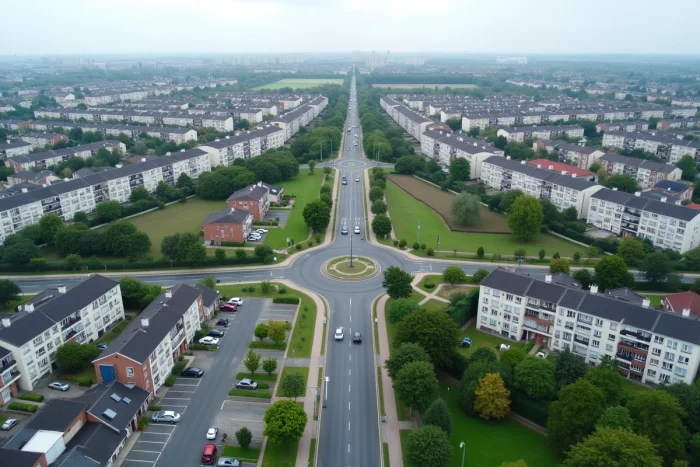
INSEE defines the suburb as the set of municipalities within an urban unit that are not the central city. The built fabric is continuous: less than 200 meters between two constructions. The peri-urban area, on the other hand, corresponds to the municipalities in the outer rings of urban areas, where a significant share of the workforce works in the urban center while residing in a space with discontinuous built fabric, often dominated by single-family homes.
Further reading : How to Choose the Right Sports Equipment: Essential Tips and Trends
This distinction is therefore based on two measurable criteria: the continuity of the built fabric (suburb) and the home-to-work commuting flow towards the center (peri-urban). In practice, this means that a suburb municipality can be the same distance from the city center as a peri-urban municipality, without belonging to the same administrative category.
To understand the difference between suburbs and peri-urban areas, it is important to keep in mind that zoning evolves with each census: a municipality classified as peri-urban can shift to suburb status if urbanization fills in the interstitial spaces.
You may also like : How to fix the van 79 error on Valorant and resume your game

Climate Law and DPE: an unequal territorial impact on the housing stock
The Climate and Resilience Law of August 22, 2021, gradually prohibits the rental of homes classified G and then F in the energy performance diagnosis. This measure does not affect the two types of territories in the same way.
The older single-family home stock in peri-urban areas is more exposed than the collective housing stock in suburbs. Suburban buildings, often connected to heating networks or stemming from recent construction programs, generally show better thermal performance. The houses from the 1970s to 1990s, typical of peri-urban areas, combine large heating surfaces with insulation that is rarely renovated.
Several notarial analyses and those from FNAIM have noted since 2022 a slower increase, or even stagnation, of prices in certain energy-intensive peri-urban sectors, whereas well-served suburbs maintain a more sustained price dynamic. The DPE thus becomes a factor of territorial differentiation that did not exist ten years ago.
Fifteen-minute city and peri-urban centralities: the boundary blurs
Since 2020, several major French urban areas (Paris, Lyon, Nantes, Bordeaux) have integrated the concept of “fifteen-minute city” into their planning documents, whether they are PLUs or mobility plans. The principle is to make daily services accessible within a fifteen-minute walk or bike ride: school, shopping, healthcare, leisure.
The effect on the suburb-peri-urban distinction is direct. Some centers of small peri-urban towns are now designed as proximity centralities offering the same services as a well-equipped suburban neighborhood. Municipalities classified as peri-urban are investing in health houses, coworking spaces, or covered markets to reduce dependence on cars, a historical criterion of peri-urbanization.
This movement does not erase the statistical reality of INSEE zoning, but it creates situations where the daily experience of a peri-urban resident approaches that of a suburbanite in a well-equipped municipality. Field feedback on this point varies: some peri-urban elected officials observe a real upgrade in local services, while others emphasize that the network remains too loose to fulfill the promise of fifteen minutes.
Mobility and car dependence: the true distinguishing marker
Car dependence remains the most tangible criterion for distinguishing suburbs from peri-urban areas in everyday life. Peri-urban spaces have been structured around the massive use of cars, as described in urban geography literature since Newman and Kenworthy’s work in 1989.
In suburbs, density allows for service by heavy public transport (metro, tram, high-level bus). Households there more often have an alternative to the car, although the availability varies from one municipality to another. In peri-urban areas, the majority of home-to-work trips are made by individual car, due to a lack of profitable lines for transport operators.
This reality directly impacts household budgets. It also explains why energy transition policies (low emission zones, rising fuel costs) hit peri-urban residents harder, whose daily commutes are longer and for whom mobility alternatives remain limited.
Three concrete markers to situate a territory
- The vehicle ownership rate of households: higher in peri-urban areas, it reflects the absence of a credible alternative to the individual vehicle for regular trips
- The share of individual housing in the total stock: dominant in peri-urban areas (single-family homes), minority in dense suburbs (collective buildings)
- The travel time to the nearest employment center: often exceeding thirty minutes in peri-urban areas, shorter in suburbs thanks to transport infrastructure
Planning challenges: densifying without repeating past mistakes
The goal of zero net land take (ZAN) enshrined in the Climate and Resilience Law forces peri-urban municipalities to rethink their development model. The single-family home expansion that has characterized peri-urbanization since the 1970s now faces a restrictive regulatory framework.
For suburbs, the challenge is more about the rehabilitation of the existing stock and the requalification of commercial areas inherited from previous decades. The density is already there; the question is about its quality.
In peri-urban areas, the available data do not allow for a conclusion that gentle densification (parcel division, intermediate housing) is sufficient to meet housing needs while preserving the quality of life sought by residents. The Terra Nova report published in May 2026 advocates for a “doctrine” and “narratives” adapted to the diversity of peri-urban situations, rather than a single model based on dense cities.
The distinction between suburbs and peri-urban areas is not just a geographical vocabulary exercise. It conditions access to transport, the value of real estate in light of new energy standards, and the ability of local authorities to finance proximity services. As long as statistical zoning and the lived experience of residents do not always coincide, the debate over these two forms of territories will remain open.